|
Calibrating a mapOn this page I show step-by-step how to capture a map from Google Earth (it could be any other application) and calibrate it for using it finally with JCapPM. The captured map is independent of Internet and Google Earth and can be used in order to create a html photo album with JAlbum skin PositionMap. N E W : Since JCapPM 4.0, getting a calibrated map is much more easier because JCapPM is able to download a map from Google Maps ! Read on here for more details. Capturing map imageOpen Google Earth and center it to the region in which you are interested. 
As you see in the screenshot I'm using a kml file, which may be created by JCapPM when you import a tracklog file. The advantage to have a kml file here is that Google Earth displays automatically the region in which I'm interested. However, I deselect "JCapPM.kml" in order to hide all position points because I want to capture the map for using it with JCapPM. Ensure that North is straight up and that tilt is zero. I save the cropped screenshot to my photo folder "c:\photos\2005\Paris\_map.JPG". I return to JCapPM, open the Options-dialog (Ctrl-O) and tell JCapPM the name of my map image "_map.JPG" as the following screenshot shows: 
After clicking on "Apply and save settings" JCapPM shows me the map captured from Google Earth. Calibrating mapNow I have to calibrate the map for JCapPM by setting a reference point and by defining a distance. First I set the cursor point (red point) at a distinctive place and I click "Set reference point..." in the "Settings" menu: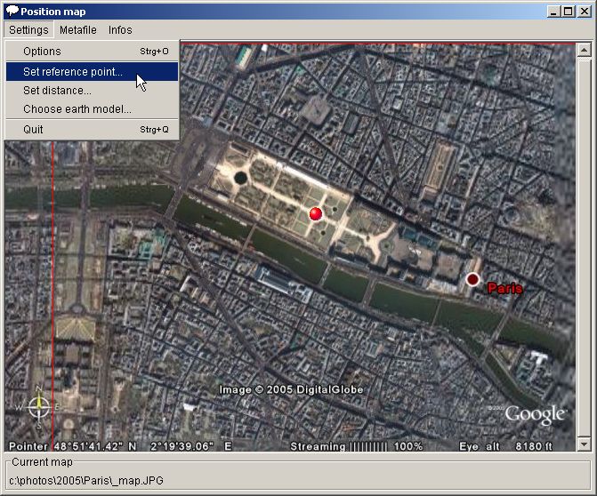
I turn back to Google Earth and set at the same location a placemark. By activating the "Advanced" option Google Earth tells me the exact Latitude and Longitude: 
These I copy to JCapPM: 
Pay attention to the format of latitude and longitude. As you see, longitude degrees (DDD) have to have 3 digits, so I had to add a leading zero. If I had forgotten this zero, JCapPM would think I mean 219°45.12' which wouldn't work since the max value of degrees is only 179. Minutes (MM) and seconds (SS) have to have 2 digits though. Ok, I save the reference point and JCapPM proposes me to define the distance. I click OK and place the red hair cross at a distinctive place, prefering a large distance to the red cursor point: 
I turn back to Google Earth and measure the same distance using the same measuring unit as choosen in JCapPM (meters): 
Back to JCapPM, I enter the value: 
Converting lon/lat to x/yAnd now, the last step consists in converting longitude/latitude datas, which were imported in one of the first steps of the tutorial, to x/y coordinates in order to show our position points on the screen.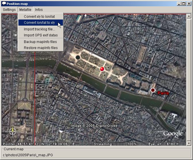
And here is the result: 
All photos are now shown with their geo position! And comparing it with the Google Earth result I would say that there is no visible deviation :-) I could now add other position points or areas or lines or angles of view. Since the map is calibrated, JCapPM writes automatically longitude/latitude besides x/y coordinates to the meta file. The next step could be to generate a html photo album with JAlbum/PositionMap. So you could burn the photo album on a CD-ROM and present it to anybody even if they don't have access to Internet nor Google Earth. Isn't that cool!? |